Saturday, December 8, 2012

Rounding Out 2012

Sebring, FL. It's a rainy Saturday evening as I just completed the long ride of the three-day Highlands Bicycle Festival. The local bike club puts on this festival every year in early December. It's a great opportunity for us Northerners to extend the season by a few weeks. Today's ride was a sunny 80 degrees with billowing clouds and light winds. Florida was reliably flat -- although the locals had some up-ramps that they call hills. This brings to a close my most successful cycling year, yet.

Mississippi River Trail, New Orleans, LA
But, let me update the project. Shortly after the No-Hill Hundred in early October in Nevada, I completed a century along the Mississippi River Trail in New Orleans. The levee makes a nice, quiet cycling environment, although it is somewhat lacking for shade. There are wonderful views of the shipping -- large and small -- moving along the Big Muddy. The trail ends in the western reaches of downtown New Orleans, so I had a chance to ride among the famous streetcars. The ride also provided a sampling of much of the heavy industry along the Mississippi shore, from grain elevators to oil refineries, and the rail lines that serve them. The small towns and plantation houses, many of which grew up as river landings before a levee separated them from the river, seem to cling to a tenuous existence.

And the immense hydraulic potential is evident just to the north of the trail, as the gigantic mile-wide Bonnet Carre Spillway stands ready to divert the Mississippi into Lake Pontchartrain. It strains the imagination to consider a river this large needing an additional river-size spillway to handle a flood. But, we're talking about all the precipitation from Pittsburgh to Denver and everything in between, so there's half a continent's worth of watershed to account for.

Thus, Louisiana became state number 48.

In late October, I enjoyed the second annual Longleaf Trace Century in Hattiesburg, MS. This 'trace' is an award-winning rail-trail that runs some 40 miles to the west of Hattiesburg. It is the crown jewel in a network of greenways in this university town. The Trace shares the same feature of most rail-trails: it is flat. But, to add enough miles to make the ride a century, the organizers added a little off-the-trail spice to the mix. So, while the trains of old enjoyed a well-graded right of way, the surrounding terrain undulates. This in-the-wild section was in the middle of the ride, so the beginning and end provided no surprises.

And, with Mississippi, I now have 49 states.

Saturday, October 6, 2012

A Century On the Ground

Fallon, NV. (Oct. 6, 2012) Today, I finished the No Hill Hundred, a pretzel-shaped ride through the paved byways of the high Nevada desert. It was sponsored by the Churchill County Cyclists and the Churchill County Parks & Recreation. Fallon is the home of a Naval Air Station (famous for its Top Gun school), and deems itself the "Oasis of Nevada". It's located at the junction of US routes 95 and 50. As you can tell from the satellite image, they have a good nickname. This is anything but barren desert.

The terrain delivered as promised: there were truly no hills. Of course we did ride mile after mile in the same gear, but that was a small price to pay. The route was well-marked, and the rest stops well-stocked. This is their tenth year running a century in flat Fallon.

Fallon is at 4000 feet of altitude. I think that took a little edge of my riding pace. I found myself out of breath if I took too long a drink while riding. It's hard to get acclimatized when you fly in two days before!

October is a comfortable time of year to ride in northern Nevada. The temperature peaked in the 70s, but the ride began at about 40 degrees. The air was so dry, however, that you could ride with just a light covering. There is even some color-shifting foliage here. The brush turns yellow and the trees get some color. There is one plant that gives off a delicious smell, but I could never identify it. That's one of the benefits of riding a bike instead of driving a car.

Of course, being able to smell the environment can also be a disadvantage. Livestock stink. And, cattle seem to stink the worst. I remember pedaling a little faster to get out of the plume!

Horse farms abound. There were stables, horses, and trucks with horse trailers. What I never saw, however, was a single person riding a horse! As we rode past the corrals, the horses would watch us enviously.

This is Top Gun country. You are greeted by an A-7 (carrier-based attack aircraft, no longer in use) on a high pedestal. The course in fighter tactics, made famous by the Tom Cruise movie, was originally located in Miramar, California. It moved to Fallon Naval Air Station  in 1996 to become part of the Naval Strike and Air Warfare Center. East of Fallon, the Navy operates an instrumented "range", where the airspace is digitally monitored. I think we passed several of the monitoring stations along the way. There are only four courses a year, so the chances of seeing any combat aircraft on an October Saturday are slim. In fact, even though we circumnavigated the Naval Air Station, we saw no activity at all.

On the day of the ride, Fallon becomes home to a completely different kind of  'gunslinger'. The Cowboy Fast Draw Association runs the World Championship - Fastest Gun Alive contest in Fallon on the same weekend as the century. So, the hotel lobby was an interesting mix of people dressed in old western gear (gunslingers need realistic townspeople in the background!) and colorful spandex-clad cyclists.

For those of you who have lost count (and who hasn't??), this is state number 47. Three more left to go!

I only put the best pictures on this blog. I will add to the Webshots archive of bike photos, including a picture of the rest stop under the A-7, the sluice gates for irrigation, the only hill in town, and the start and finish arch, later this week.

Wednesday, September 26, 2012

Blogging is Light When the Weather is Great

Springfield, VA. I just got back from a mid-day, mid-week bike ride through a nearby park. I enjoyed 32 miles of quiet park paths or neighborhood streets abandoned for the dungeons of work and school. It was a sunny 65 degrees with light winds. There is a hint of color in the foliage this first full week of fall. September is a great month to be retired!

Although I've acquired no states since my trip to Wisconsin, I've been able to ride a century for both of the past two weekends. On the 16th I drove up to Carlisle, PA to enjoy the Three Creek Century, an annual offering of the Harrisburg Bicycle Club. I must say, I took my time because the weather was so nice and the scenery was so pretty.

Last weekend was our own bicycle club's century. The Potomac Pedalers offers the Back Roads Century in Berryville, VA. I helped out with preparation on Saturday so that I could do the ride on Sunday. The day was a perfect copy of the previous week. Again, I lingered at the White Post rest stop, munching on the club's famous 'tomato sandwiches'. (I had loaded the pallets of said tomatoes onto the truck the previous day, so this was the fruit of my volunteer labor!)

Carlisle, PA
With all this nice weather it's becoming obvious why, years ago, the League of American Wheelmen, designated September "National Century Month". This was, of course, back when the LAW sanctioned, supported, and helped to organize centuries. Now there is no national century organization.

This is all prologue, however, to my upcoming frenzy of states. This coming weekend I'll hit state #47, Louisiana, with the Crescent City Century. The following weekend, I'm booked for state #48, Nevada -- the "No Hill Hundred". Somebody asked me if that was sarcasm, and if the ride had a lot of hills. I had not thought of that! I'm going to be checking the website and the map profiles.

And, on Saturday, October 27, I plan to collect state #49, Mississippi. The 'Longleaf Trace', a large rail-trail near Hattiesburg, offers their second annual century ride. That will color in the continental US red from sea to sea and border to border.

Hawaii will be left. I'm in the process of booking a Backroads bicycle tour of the big island in January. After that there's nothing to do but write the book!

Sunday, September 9, 2012

100 Miles of Wisconsin Shoreline

Sturgeon Bay, WI. Door County is the peninsula to the northeast of Green Bay. It's a beautiful part of Wisconsin, rolling farmland, small coastal villages, and quiet roads. It sometimes bills itself as the "Cape Cod of the Midwest", but this is like Cape Cod of the 1950s -- before the tourism and development. The Door Country Century is an annual event with a long history. It moves north from Sturgeon Bay along the coast, visits several beautiful parks, beaches, and coastal overlooks. The century finishes with a 30-mile flat ride along the east coast.

It was a perfect day: temperatures in the mid-60s and winds from the north. Thus, for the latter half of the ride, we had the wind at our backs! The rest stops were superbly organized, and even near the end of the day everything was available. Each stop had its special feature: strawberry shortcake, cheery pie, or cheese curds. (It is Wisconsin, after all.)

So, the Burma Shave signs said:
   We love bikers!
   We cheer for riders!
   And the Packers!

Saturday, August 18, 2012

South Dakota - Saving the Wind to the End

Watertown, SD. Today I completed 100 miles among the lakes and byways of northeastern South Dakota. It was a pleasant day for most of the ride: light winds, no hills, and good roads. But the fun was not to last. The final 20 miles were northbound into an uncharacteristic headwind. (Winds in these parts blow normally from the southwest.) I was on track to have made this one of my fastest centuries, but a quirky breeze held me back. I watched my average speed bleed slowly down to just normal.

The lakes that give Watertown its name were really quite pretty. As I traveled, numerous birds would launch themselves from the shoreline.The mirrored surface reflected the billowing clouds from the sky, which seemed to move along the lake surface as I ride.

The local club, the Watertown Bike Club, did a great job setting up the ride. The road markings were pretty easy to follow, and the SAG stops seemed to appear just as I needed them. Plus, the volunteers were friendly and cheerful, and all of us enjoyed the 70-degree sunshine. They had designed a route that would normally get a tailwind at the end, but Mother Nature decided not to cooperate.

I'll add more pictures and narrative in the days ahead, but right now I need my post-century beauty sleep!

Friday, August 10, 2012

Alaska - This Is Why We Bike


Valdez, AK. Today I completed 100 miles of bicycling in the Alaskan wilderness. I started in Copper Center, along the Copper River in central southern Alaska, and finished in the port of Valdez. It was a wet, windy ride, and we were swarmed by mosquitoes when we stopped. But, the scenery was amazing (along Alaska route 4, following the route of the Alaska pipeline). I'm in Alaska as a guest of a Backroads tour company bicycling trip. This is the "century day" on the trip.

Alaska was every inch as stunning as its reputation. Today's route began on a bluff overlooking the Copper River, with four massive volcanoes in the distance: Mts. Sanford, Drum, Wrangell and Blackburn. We crossed the green, glacier-fed Tiekel River twice, and moved up the valley of the Tsaina river. We had lunch at Mt. Billy Mitchell, which is an imposing, Matterhorn-like peak over route 4 that you can see for miles. The Worthington Glacier sat off to our right as we climbed Thompson Pass.

The day finished with a rainy 2300-foot descent to the coastal plain along the 'braided' Lowe River, which gushes into Prince William Sound. But, on the way down we see the magnificent Bridal Veil Falls and Horsetail Falls. I pulled into Valdez drenched but triumphant.

I posted many of my pictures to Webshots. The link will show you the whole album. We've had five days of bicycling in the Alaskan wilderness. This is not normally a part of Alaska that tourists see: the loop between Palmer and Valdez, connecting via ferry back to Whittier and Girdwood, and finally back to Anchorage.

Along the way there were points where cars could not pull over -- there was only a half-shoulder behind rumble strips. It was perfect, however, for a cyclist to stand and take a picture. Thus, many of the pictures in the Webshots album could only have been taken by bicycle.

As you may imagine, my century time was much delayed by the climbing, the headwind, the rain, and the large number of photo stops. I don't really treat a century as a race, however. This has been one of the most memorable -- both challenging and rewarding. This is why we bike!

Saturday, June 23, 2012

Wyoming's Tour de Prairie

Cheyenne, WY. Today was the annual Tour de Prairie, which is part of the Cheyenne Parks & Recreation's "Superday" celebration. About 200 of us rode out Happy Jack Road, past the wind farm, and into the hilly approach to the Continental Divide. It was along this general route that Grenville Dodge first surveyed the Transcontinental Railroad.

The century climbed to the highest point on Interstate 80, where there is a monument to Abraham Lincoln. This celebrates the Lincoln Highway, the nation's first macadam road to cross the continent.

The steady west wind turned this into two separate rides. There was a grueling "out", in which every turn of the crank was an endurance test. The winds were 18 mph gusting to 25. There were no clouds, and there was about 3000 feet of climbing. This was followed with an amazing "back", which was all tailwind and mostly downhill.

Shade trees are rare in these parts, and the daytime high was over 90 degrees. So, hydration was a vital part of survival for the ride. The organizers had great, well-stocked rest stops at appropriate places. And, the Gatorade was widely available.

We passed the 14-turbine Happy Jack Wind Farm. The blades were whirling all day, easily generating their 29 MW of power. They are impressive structures as you pass by them on your leetle bicycle!

Saturday, June 16, 2012

North Dakota: Wind-swept Flatland

Fargo, ND. I just completed the Tour de Cure, one of the many organized charity rides to defeat diabetes. The route was simple: a square of four 20-mile legs followed by a 10-mile 'tail' into Minnesota. And, it was flat: the only time I had to climb was the overpasses over interstate highways.

As with all the rides in the Great Plains, wind presented a challenge. In this case, the wind was forecast to blow from the East, and instead came in from the West. Our first leg was a westbound leg early in the morning. Winds are light in the morning, so we missed a headwind at the start. This was followed by a southbound 20 miles in which we struggled with a crosswind. As I've said before, crosswinds can be nearly as challenging as headwinds.

But, from mile 41 to mile 61, we were propelled by a powerful tailwind, and most of us flew down the road on 'afterburners'. It was like getting on board a moving walkway at the airport -- even when I coasted I was doing 15 miles per hour. The northbound leg was another crosswind grind, and brought us close to the start with less than 80 miles completed. Thus, we added an East- West out-and-back across the Red River into Minnesota. Going East, we could bomb down the road again. But, once we turned around, pushing the final 15 miles into a stiff breeze drained everybody's battery.

I left early to be sure to finish by the organizers' stop time (3PM). Little did I realize that they made and announcement to recognize me at the group start. Thus, when I mentioned my 50-century project at one of the rest stops, several riders said, "So you're the guy! They were looking for you."

I hate being rude, and I appreciate their good intentions. But, I've found, if I don't leave early, I end up doing the ride pretty much alone. Nobody else, it seems, does my leisurely 60-year old pace. But, I appreciated the enthusiastic cheering squads at the rest stops and at the end of the ride. Lots of pom-poms and, of course, cowbells!

As most flat rides, there is not much to say in the scenery department. Farm followed farm, all of them huge. Occasionally, there would be horses. Roads in this part of the country go to the cardinal directions of the compass. Only the railroads get to go on a diagonal. The country is so open, that you can see all 120 cars of a freight train in the distance. (Okay, to help pass the time and the miles, maybe I did count the cars on the freight train while I was riding.)

This is Burlington Northern Santa Fe country. Union Pacific doesn't go anywhere near North Dakota. Add to that, the occasional short line such as the Red River Valley & Western. I saw lots of BNSF traffic. At one point near the end, I was racing to a crossing as a BNSF train was approaching (from the distance). I realized that I was increasingly likely to make it across before the gates closed. This made no sense -- with a headwind at mile 91 I am NOT faster than a a speeding locomotive! It turns out, the engineer must have had a stop signal, as his train coasted to a stop about 200 yards from the road.

Sunday, June 10, 2012

A Little Tour de Rock

Little Rock, AR. I just finished the 2012 Tour de Rock, a 100-mile loop through the Arkansas bayous east of Little Rock. This ride supports the Central Arkansas Radiation Therapy Institute, or CARTI. CARTI helps cancer patients, and is, according to everyone I spoke with, one of the best places to work in town.

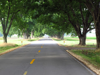
A Tunnel of Trees near Mile 30
The course was flat, the second half of the ride had a great tailwind, and the temperature just brushed 90 degrees. Those are pretty good conditions. There were some beautiful sections, including the ride along the river at the start and the finish, as well as a nice segment through pecan groves on route 161 (pictured).

I followed my mantra, "Start First, Finish Last, Have the Best Time," with precision. I jumped the gun at the starting point (to beat the heat), moving across the Big Dam Bridge about 20 minutes early. And I was, in fact, the last one to finish at just before 3PM. That was not my plan, but there were several people behind me who dropped off during the ride. I always feel a little guilty when I'm last, as if I'm holding people up from the rest of their day. But, it really did not seem to be a problem for folks, and they probably had to spend the time breaking down the rest stops anyway.

This was a superbly organized event. The rest stops were well stocked, especially with lots of pickles. (Pickles, I have discovered, may be important in suppressing leg cramps.) The rest stop spacing was about every ten miles after about mile 30, which was quite helpful. There was no chance of getting lost -- the course was marked with large, red arrows that could be seen for half a mile. And, there were ever-present SAG and radio vehicles.In fact, as I was the tail end of the ride, I had a SAG escort for most of the last 50 miles.

Some riders find the presence of a trailing SAG vehicle bothersome. That's because you sometimes want to enjoy the road to yourself -- especially when it's a quiet country lane. But, for me, it was nice to know that there were people looking out for me when I was so far from home. It was a nice change from some organized rides, in which a late rider arrives after riding for hours alone to find an empty parking lot. Besides, it was a motivator to keep up my pace and a witness to the fact that I finished the whole ride.

I have to call out the unique support of the police and sheriffs in this ride. Normally these large rides start with a police escort through town, and we had that. Roads were blocked and we were waved through intersections in downtown Little Rock early Saturday morning. But on this ride, the support was made available to the old stragglers like myself at key intersections well into the afternoon. Two police cars and a motorcycle cop stopped traffic on busy US-165 at 1:30PM, allowing me to blast through the intersection. I felt like a celebrity with all the escorts and flashing lights. I thought that would be all, but at one more busy intersection, a Little Rock officer held traffic so I could roll through at 2:30 in the afternoon. It was a nice touch that I had not seen anywhere else.

There volunteers set a new high-water mark in friendliness on this event. They all seemed to know what cyclists want at various points. On a warm, sunny afternoon, they had set up a garden hose as a 'mister' to cool us off at the 90-mile rest stop. As soon as we arrived at a rest stop, they ask to fill our water bottles. (Pushing water and hydration is just a good idea. Some people fail to realize how important hydration is in the last 20 miles or so, and skip drinking and even skip rest stops.) And, as feeding my ego is very important (to me), many folks were interested in my 50-century project. I think the rumor that I was on this quest made it to later rest stops before me, as several folks asked me, "Are you the person who's doing a century in every state?"

Well, yes, I am that man, and this is, in fact, the blog I told you about. I hope any new readers enjoy the many entries, and take pleasure in following me to the end. It will not be long now: 41 states down, and nine states to go!

Thursday, June 7, 2012

Ohio: Lingering on a Perfect Day

Xenia, Ohio. One of the benefits of riding a 'do-it-yourself'' century is the ability to control the timing. Thus, if the weather is sparkling (70 degrees, no wind, etc.), then you can take your time doing 100 miles. Xenia is the intersection of five, long rail-trails. There is s substantial infrastructure for cycling, including some rebuilt 'train' stations with amenities. The trails are all paved, and, as they follow the old railroad, have only the slightest of uphill & downhill grades. Is there any wonder that I would linger in this area?

The Little Miami Trail is the main trail through Xenia. The Creekside Trail leads West to downtown Dayton. There's an Eastbound Prairie Grass Trail out of town that goes for 29 miles. Finally, the Jamestown Connector begins (now) just out of town. The plan is to connect it under route US-35, but that may take several years.

Who Would NOT Want to Linger on a Day Like This!
Giving myself  permission to linger, I stopped at a well-known ice-cream place in Spring Valley. At 93 miles, just about any ice cream is going to taste great, but this was truly delectable.

It was a bittersweet moment as I rode into the Xenia Station parking lot for the last time. I was tired, to be sure, but I left with deep appreciation for the attention local governments have paid to creating a massive (and paved!) cycling network.

Wildlife: This was a major cardinal-viewing day. They seem to like to swoop across the trail in front of a cyclist. Two deer crossed the trail in front of me, and I thought I got a picture. Alas, it did not come out. I saw a chipmunk hiding in a hole in the asphalt on the trail. The cottontail rabbits seemed to enjoy scampering in the grass on the margins of the trail. I shot a picture of a tern in the Mad River near Dayton, as I avoided the 'evidence' of the several flocks of Canada Geese.

With Ohio, the state count is now up to 40! And, in two days, I will add Arkansas to the total.

Tuesday, May 29, 2012

Horsey Hundred: Hot and Hilly

Georgetown, KY. I completed some 130 miles of Kentucky bliss this Memorial Day weekend. The Bluegrass Cycle Club hosted the 35th annual Horsey Hundred in the hills and dales north of Lexington.

People often ask me what I will do once I finish the Fifty Centuries Project. At least one thing will be to return to do the best rides again. I got a good start on that with this ride, as I've already colored in Kentucky. I did the Horsey Hundred back in 2003, but the memories were so vivid that, every Memorial Day weekend since then, I've realized (too late, of course) that I could be in Georgetown with hundreds of my fellow traveling cyclists.

Shade Saved the Day!
This year, the weather was hot. Every year the course is rolling hills from start to finish. (I don't think there were any flat stretches at all.)

This was a shady ride: most of the roads were crowned by leafy trees, as you can see. This picture repeated itself again and again (with a different cyclist passing me of course). The few places where we had to climb in the sun made us notice how much shade there really was.

And there were horses, and "horse toys": magnificent stables, plush estates, and even a specialty business at the airport to provide "luxury equine travel" by air. It was foaling season, so there were lots of foals (horses younger than one year) around. (These are not ponies, by the way. A pony is a small, mature horse.) Georgetown College has a building devoted to "Equine Studies", and it's larger than the Economics building.

Less evident on the landscape is the whiskey culture. It is said that there are more casks of bourbon aging in Kentucky than there are residents!

Galloping Horses near Versailles, KY
This ride draws people from all points of the compass. There were Canadians, Carolinians, and Californians. I met a few from Texas, and I'm sure I wasn't the only person from Virginia. (I saw some cars with Virginia license plates driving with bicycles attached along I-64 on the Friday before the ride.) There are a lot of people like me who enjoy traveling to ride (as opposed to bicycle travel, which can be grueling). I think we need our own support group.

Saturday, the day of the big ride, rose to 93 degrees. The last two hours were decidedly unpleasant. So, in the future, should wind or heat take the joy out of afternoon riding, I will opt for the 75-mile option. You see just as many covered bridges, horse farms, shady lanes, and panoramic vistas.

Sunday, May 20, 2012

Wichita's Wicked Wind 100 Was Windy

Wichita, KS. Today I completed 101 miles through the Kansas prairie. This ride was named the "Wicked Wind 100", and it certainly lived up to its name. Actually, the wind blew directly down from the North, so it was a blessing that the ride went mostly East-West. A crosswind, however, can wear you out as well.

Normally I avoid century rides that include an additional challenge, such as heat or hills. That's why you'll never see me on the Hotter than Hell Hundred, or almost anything with the word 'challenge' in the name. I figure a century is challenge enough, so there's no need for additional seasoning. And, of course, remember the mantra: A century should be fun!

So why would I sign up for a ride that promised wind? Headwinds are among the most demoralizing of century challenges. Unlike hills, headwinds can go on for miles and miles. And, with a ride with long, straight legs (like many in the Midwest), the result can be draining.

Well, it is Kansas after all. If I'm going to color in the Sunflower State, I'm going to have to ride into the wind. Some Kansas ride organizers don't mention the wind. I chose a ride that put it out there for all to see!

But, everything else was marvelous. The Oz Bicycle Club, the hosts for this century, laid out a low-traffic loop centering in Haysville -- just south of Wichita. There were rest stops every 10 miles, staffed by friendly volunteers and fully stocked. I particularly enjoyed the home-made chocolate chip brownies at the 80-mile rest stop. Those kept me going for the last 20 miles!

It was flat farmland, irregularly interrupted by numerous streams, rivers, and railroads. Almost every turn was a right turn in carefully-platted mid-America. Crops were beginning to fill in -- mostly wheat and corn. There were almost no hills, and, thus, very few viewpoints to see scenery. The line of sight rarely went beyond a couple of miles.

Wichita is a charming small town. It's home to Wichita State University. It is also an aircraft manufacturing hub. In addition to the Mid-Continent Airport, there is the Beech Factory Landing Field, the Cessna Aircraft Airport, and McConnell Air Force Base. There is also a Colonel James Jabara Airport, and several landing fields within ten miles of Wichita. I guess when you're too far from a marina, a private plane is the best option for disposable income. 

Saturday, April 28, 2012

Texas Toast

Georgetown, TX. Today, I completed the Red Poppy Century Ride across the rolling hills of central Texas. The Lone Star State challenged me with headwinds & heat, and I countered with gears and Gatorade and gumption. The day was mine!

The temperature only reached 85 today, and there were clouds for much of the morning. But by 2PM on a late April afternoon, the dry heat down here can knock the stuffing out of you. But the real challenge was the 30 mph wind from the south, enough to make the flags stand on end. The route was a loop with about 20 miles into the headwind, and those legs were pure torture. Even in a crosswind it was difficult to control the bike. And, the combination of heat and wind made hydration a huge challenge. In fact, the temptation to take a short cut was about as much as the Wicked Witch saying, over and over, "poppies! more poppies!".

But, I did it! I did not finish at any great speed, and I took several "granny stops", but I'm happy to say I rolled in to Georgetown High School under my own power. On the headwind segments, I geared way down and just crawled along. By the afternoon, I refilled my 100-oz hydration pack with Gatorade and ice twice. It all worked because one of the EMT techs at the final rest stop (92 miles!) said I was one of the few who had a smile on my face at that point.

I can't go without saying that Texans are great people. I don't remember getting 'buzzed' by one car. I got a lot of waves, and a lot of friendly smiles. The rest stops were stocked well, and all kinds of help was cheerfully provided. I appreciate the woman who cheered everybody in to the 40-mile rest stop. (She must be hoarse by now!) And the nice lady who offered to make me a PB&J sandwich at the 82-mile stop. And, of course, there was the woman who filled my water bottle while I was elsewhere engaged, and I didn't realize she had put ice in it until later. I tried to say thanks to them all.

And, yes, there were red poppies. Late in the day, it was easy to stop and take pictures of the fields of bluebonnets and poppies. 

It's a great feeling coloring in Texas on the map. It's such a big state!

Wednesday, April 25, 2012

A Century Should Be Fun

Last Saturday, April 21, I finished the Lake Anna Century Classic. Lake Anna was formed in 1973 when the North Anna River was dammed to provide cooling water for the North Anna nuclear plants. The irregularly-shaped lake is the third largest in the state. This ride circles the lake, and uses all but one of the bridges over the its estuaries.

It was a delightful day -- sunny and a bit breezy. We passed some beautiful homes and yards, there were many views of the lake. And, for those who kept their heads up, there were many memorable tranquil scenes reflected in water -- an old mill or a peaceful copse of trees. The terrain was not particularly challenging, but I didn't experience any of the advertised 'long, flat stretches'. We were either climbing or coasting on shallow grades. In fact, the grades so dominated the ride that I don't think I really noticed the blustery headwind. But, when we turned into the final 30 miles, the tailwind put a smile on everyone's faces.

We were particularly fortunate with the weather: the following two days were cold with an all-day rain. The nearby Appalachian Mountains even had snow! We grabbed one of the best weather days of the month.

This region of Virginia has an interesting mix of cultures. The quiet affluence of the lakeside homes stands in contrast to the rural farming communities in the adjacent counties. There were many courteous drivers who would wait behind cyclists for oncoming traffic to clear. And, there was the occasional guy in an old pickup truck who needed to voice an opinion as to whether we should be on 'his' road. When you pass through a town called Bumpass, you probably should expect a bit of that. The friend-to-foe ratio was about twenty-to-one, which is as good (or bad) as it is country-wide.

I've ridden on these roads before, as early as the 1980s. It's interesting to see the Virginia Department of Transportation in transition. Long ago, there was absolutely no accommodation for bicyclists. Now, some of the roads have shoulders. But, maddeningly, the shoulders have a tendency to disappear -- sometimes just as you're climbing a hill with traffic coming in both directions. Instilling rationality in road design is one of the reasons I've become involved in bicycle advocacy with our local government. 

For some odd reason, this 'century' went only 95 miles. This makes no difference to my quest, as I've long since colored in Virginia. I have to wonder, however, if there isn't some way to gather up an extra five miles of the rolling Virginia countryside.

But, as I did this ride, my thoughts centered around how pleasant this whole experience was. That includes the anticipation and the mapping ahead of time, as well as the post-ride chatter with fellow riders. On some rides, I want to put on earphones and listen to something to make the miles move faster. The scenery here had so much variety that I was well into the final stretch before I pondered adding a soundtrack.

Interestingly, century events seem to come in distinct sizes. This was a 'small' event, with about 200 riders. The Tristate Century earlier in April was similar in size. There are many events with thousands of participants. It's sometimes hard to tell ahead of time what the scale of a given event will be. I'm expecting that soon enough I'll be riding with a bigger crowd.

Perhaps next weekend: The Red Poppy Ride in Georgetown, Texas. And, after that event, I'll get to visit my grandchildren! Life is good.

I've updated the links at the right to show the rides I'm registered for on the rest of the year. You may have noticed a theme: I gravitate toward those rides with "flat" in the title, or that advertise the avoidance of hills. After all, a century should be fun!

Thursday, April 5, 2012

Tri-States Century

Dothan, AL. I just completed my first century of the season. I rode 102 miles through southeastern Alabama, northern Florida, and southwestern Georgia. Thus, I'm now able to color in the entire southeastern corner of the map.

The local bike club has put on this ride for ten years, now. Proceeds go to the Pediatric Cancer Unit at Birmingham's Children's Hospital. Our ride included 17 wounded warriors, who were so fast that I did not see them all day.

Now, the truth has to be told: I was the last rider to finish. The way I see it, a bicycle ride is a journey, not a race. I feel like I got the most out of the ride: I spent the most time in the sunshine of a beautiful day. Lots of great volunteers staffed lots of rest stops, and really expected the last rider to finish later. So, when I got in, everybody got to go home early!

Dothan has a number of cycling events in conjunction with its CityFest. In fact, the Mayor wished us a good ride at the start, standing with a bullhorn and fully decked out to ride (helmet and all!) Thus, motorists are used to seeing bicycles on the roads. I found the good people of this rural region to be among the more congenial drivers I've encountered.

And, I was impressed with the enthusiasm of the volunteers. At every rest stop they would cheer or wish me well. The would not hear of my apologizing for being slow. We laughed about all the hills left to go (most of the hills were in the last 20 miles). But the course was spectacularly well-marked. In fact, they had spray-painted words of encouragement on many of these last few hills. "You LAUGH at hills!" was one of my favorite. And, I did.

You know, I finish a lot of centuries on my own. By the time I get back, almost everybody has packed up and gone. I've gotten used to it, so it's not a big deal really. But, when you arrive at the finish line to a small crowd of cheering people, high-fiving you, shaking your hand and asking, "How many states is that?", it is one of life's delicious moments.

So, for all that amazing southern hospitality, I've put the Tri-States century on my list of "go backs". When I finish this project, over the coming years, I'll keep an eye out for the early April running of future "TS-100"s.

Friday, March 2, 2012

New Zealand Bicycle Tour


I just completed a ten-day, 330-mile bike tour of New Zealand with Backroads Touring Company. My original intention was to blog occasionally during the trip. The good news is that there was too much time on the bike and too much to see and do. So here I sit in the airline transit lounge collecting my thoughts and working hard to remember the best parts.

I’ve been wanting to do this trip for several years. I was one of the six percent of people (according to a tourist office survey) who said that the Lord of the Rings movies motivated me to want to see New Zealand. That, and a late-winter trip helps launch my century season. I was accompanied by eight other Americans – three couples and two women traveling solo. With our leaders Brad and Kevin, we were our own happy fellowship, all enjoying vacation, retirement, or a great gig as a New Zealand bike tour guide. Some of my companions were using this trip to train for their own athletic challenges – mostly marathons and triathlons.

I may have been among the slowest of the group, but I spent a lot of time taking pictures. In fact, I filled my camera card with eight hundred pictures. The best I will post online at webshots. (Readers, do let me know if this does not work!)

Much of New Zealand’s allure comes from its extensive undeveloped regions, some of which are completely undisturbed wilderness. We toured entirely on the South Island from Christchurch, making our way south along the West Coast, traversing the Southern Alps and ending in Queenstown. Much of this area is a temperate rain forest, sprinkled with a few, very small settlements that are separated by dozens of miles of heavy, primordial brush. The road through this region was not completed until the 1960s, and it was another several decades before it was paved.

Despite the fact that the voyage was coastal, you will see precious few pictures of the beach. West Coast beaches are uninhabitable due to the powerful undertow and the ever-present sand flies. These aggressive, biting insects made it difficult to even take pictures along the shore, swarming around any exposed skin and announcing their attachment with stinging bites.

Even though February is summer in New Zealand, this was a wool-and-Gore-Tex trip. We had hard rain for four of the nine days. Much of the rest of the time the landscape was shrouded in a grey mist. I found myself stopping any time the sun came out in order to gather some memorable pictures. And, near the end of our trip, we woke up to find the mountain peaks dusted with an early snowfall.

There was a lot on the balance sheet to counter the weather. The rain made everything green, including trunks of trees and road-side rock faces. The West Coast has little farmland, and there were long stretches when there was absolutely nothing. At several points we passed signs like, “Last Gas for 90 km”. The Kiwis themselves are wonderfully eccentric and care-free. In fact, you really have to remember that they expect you to look after yourself in these parts. I had to remind myself that this was, sometimes, a country with no guardrails.

And, the food! Lamb that melts in your mouth; delicious salmon; great-tasting beef, fish, cheeses and baked goods. We all bicycled hundreds of miles and gained weight. Every meal was a memory. Many of us, when asked, thought that the lunchtime visit to a salmon farm gave us the best meal of the week. Perhaps it was because we were chilled from the rainstorm, but the salmon chowder just hit the spot in such a way that we remembered for days.

Wednesday, February 15, 2012

First Century of 2012

Last month I finished the Phoenix Metro Bike Club’s Casa Grande Century. This loops through the desert from the southern suburbs of Metro Phoenix through Florence, Coolidge, and Casa Grande. It’s flat, but the desert can deliver some potent headwinds. Today was no exception. The early hours of the day were calm, but by the time we reached mile 55, a serious breeze was blowing from the northeast. Thus, the final half of the ride was an upwind grind. I’m happy to say that I was able to pour on the coal for the final 15 miles, maintaining about 13 miles per hour into the wind along Arizona route 87.

The PMBC runs a nice century. It starts at a civilized hour of 8AM, but one should arrive early to avoid the lines at the check-in table. This is one of the only centuries in the country in January! One should also bring something warm for the morning chill. While Arizona temperatures reach the upper 60s in January, the mornings can be a bit chilly – especially on the hands.

At first blush, there’s not much to day about riding in the desert: cactus, sagebrush, crows and buzzards. In reality, if you’re paying attention, there is a lot going on. There is significant agriculture out on the Arizona desert. I passed numerous irrigation canals, pumps, waterworks, and sluice gates. In one area around Coolidge, cotton was a major crop. It was so prominent that balls of cotton lined the road everywhere. Remnants of this year’s harvest could be found for miles, including along the roads leading into the large town of Casa Grande. At one point they looked like little piles of snow.

And there was cattle. Every now and then we would pass a cattle feeding pen, or get passed by a cattle truck. At times like these the wind became a bit more friendly, carrying the unique smell away quickly.

There were orange groves as well, ripe with un-harvested fruit. And, citrus fruit stands sprouted along several intersections.

For a cyclist, development and growth in Phoenix is a good thing. The road designers have been pretty consistent at establishing bike lanes along the major arteries of suburban Phoenix. On this ride, we were able to use bike lanes only in a few areas, but they were a welcome respite to the shoulder-less roads of the old days. The ride organizers advertised the use of ‘low-traffic’ roads, but this Sunday in January seemed to draw a lot more traffic that I had pictured with such a claim. Doesn’t anybody watch the NFL playoffs in Phoenix?